Chapter XII: Ararat Anomaly and Durupinar Site
May 11, 2013
In the early 21st century, the two main candidates for exploration emerged: the so-called Ararat Anomaly, and a site called Durupinar near Iran and Dogubeyazit, eighteen miles (29 km) south of the Greater Mount Ararat summit.
Professor Porcher Taylor of the University of Richmond said: “When the remains of Noah’s Ark is on Mount Ararat, the only one of the most logical location is in the Ararat Anomaly”.
Notes 45: Prof. Porcher Taylor
Source Image: magazine.richmond.edu
Ararat anomaly is an object appearing on photographs of the snowfields near the summit of Mount Ararat, Turkey. It was first documented during the U.S. Air Force conducted aerial reconnaissance mission in 1949.
Wikipedia says:
“The anomaly is located on the northwest corner of the Western Plateau of Mount Ararat (approximately 39°42′10″N 44°16′30″E) at about 15,500 ft (4,724 m), some 2.2 km (1.4 mi) west of the 16,854 ft (5,137 m) summit, on the edge of what appears from the photographs to be a steep downward slope. It was first filmed during a U.S. Air Forceaerial reconnaissance mission in 1949 — the Ararat massif sits on the former Turkish/Soviet border, and was thus an area of military interest — and was accordingly given a classification of “secret” as were subsequent photographs taken in 1956, 1973, 1976, 1990 and 1992, by aircraft and satellites.”
 Notes 46: Picture of the Ararat anomaly taken by the U.S. Defense Intelligence Agency in 1949. Previous pictures of the Ararat Anomaly kept secret by the U.S. government. Many times Prof. Porcher Taylor trying to get the image of the U.S. Security Agency, but was rejected. Taylor finally visited Insight (one of many leading magazines talk about science) to put forward ideas in using IKONOS satellite to photograph the Ararat Anomaly. IKONOS is a commercial satellites Lockheed Martin Corporation which is currently owned by Orbimage who renamed GeoEye (formerly owned by Space Imaging before it was acquired by Orbimage in September 2005). IKONOS satellite offering specialized services sensing earth observation with high-resolution imagery. Funnily enough, in 1995 a senior official at the Pentagon showed Taylor the coordinates of Ararat Anomaly (39 degrees 42 minutes 10 seconds north latitude and 44 degrees 16 minutes 30 seconds east longitude).
Source Image: 666soon.com
 Notes 47: It appears from the photos that appear Ararat Anomaly is shaped like a ship’s hull. IKONOS perpetuate these pictures in 1999 and 2000.
Source Image: 666soon.com
But one of the experts who attended the press conference NAMI team, Mr. Gerrit Aalten not agree that the remains of Noah’s Ark is located in Ararat Anomaly or Durupinar Site. This was shown through analysis that can be watched on his video titled “Mt. Ararat and Noah’s Ark Symposium 4 Report 2006“. From this analysis looks Gerrit Aalten not agree on the position of Ararat Anomaly as shown by Porcher Taylor (see picture below), as well as the anchor stone at Kazan (near Durupinar Site) which he said that the shape of the stone as it is widely spread in different parts of the world (although in fact, Aalten only shows the stones in Karahunge area at Armenia conclusively).
 Notes 48: It appears Ararat Anomaly position by Gerrit Aalten different from what is stated by Porcher Taylor.
Source Image: Film “Mt. Ararat and Noah’s Ark Symposium 4 Report 2006” on YouTube
However, the analysis of Aalten seem rather forced because he looked only at Ararat (Agri Dagi) based on what was stated in the Bible. He seemed reluctant to investigate other mountains, such as Mount Judi, Mount Tendurek, even in the mountains around Big Ararat, the Little Ararat. This is evident in the writings of the video that says “Question: … Why Mount Ararat? Answer: … “the mountains of Ararat are Mentioned in the Holy Scriptures (Genesis 8:4)”.
Subsequent statements as a justification of what is contained in the Bible without any accompanying evidence. The only evidence presented was the testimony of a historian named Akki Usta and his own investigation on Mount Ararat where he claims that what he calls the ‘Angel Rock Formation’ is the former of Noah’s Ark.
However, from the last photo that was released in 2003 Ararat Anomaly looks like it is not Noah’s Ark, but only a reef; portion of Mount Ararat (see picture below). For more information on this, you can see a video of the anomalies in YouTube.
 Notes 49: It appears the image of ‘Ararat Anomaly’ taken by DigitalGlobe through QuickBird satellite in 2003.
Source Image: 666soon.com
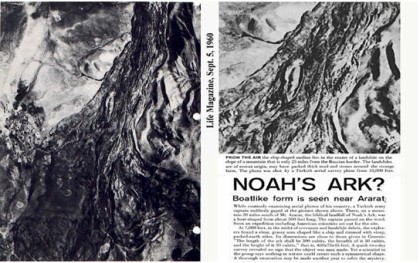
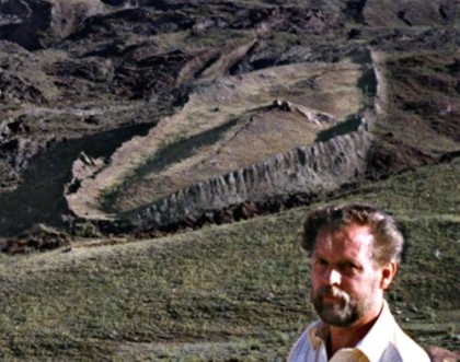
On the other side, Durupinar Site heavily promoted by archaeologist, adventurer and former nurse anesthetist, Ron Wyatt in 1980s and 1990s. Durupinar site consists of a large boat-shaped formations jutting out of the soil and rock. Nearby is a mountain named locally as Cudi Dagi (Mount Judi). Many geologists have identified the Durupinar site only as a site of natural formations, but Wyatt Archaeological Research refute the claim with no less scientific that the site is a Noah’s Ark that has been petrified.
 Notes 50: This is the Durupinar Site found by Turkish Army Soldiers, Capt. Ilhan Durupinar. The photo was taken in October 1959 by the Turkish Air Force soldier named Sevket Kurtis for NATO mapping mission. This discovery published by Life Magazine (one of the magazines in the U.S.) the September 5, 1960, where after seeing the photos of the magazine, Ron Wyatt finally determined immediately went to investigate the site in 1977.
Source Image: gregorgimmel.com (left), bpnews.net (right)
Notes 51: It appears that Ron Wyatt was standing near the Durupinar Site.
Source Image: throneofgod.com
Not far from Durupinar Site, precisely in the village of Kazan (formerly called Arzap), discovered what is believed by David Fasold as ‘drogue stone’ which is used as an anchor on the arks in ancient times. In total there are 12 drogue stones found in the village.
 Notes 52: It seems in the picture above, David Fasold (friend of Ron Wyatt) who stood beside the drogue stone which is believed to be the anchor that Noah’s Ark used when docked. Appears on the stone, there are many cross image that carved by the barbarian in the past. David Fasold known as the inventor of the ‘drogue stone’, despite the fact that Ron Wyatt et al was the one who first found it as shown in the figure below.
Source Image: en.wikipedia.org (above), wyattmuseum.com (below)
Notes 53: It seems some of the ‘drogue stone’. But Gerrit Aalten through his video titled “Anchor Stones Noah’s Ark? – Hole Stones of Arzap” which can be viewed on YouTube do not believe that the stones were used to Noah’s Ark anchor.
Source Image: Film “Anchor Stones Noah’s Ark? – Hole Stones of Arzap” on YouTube
Notes 54: Illustration of drogue/anchor stones as ark anchors. Large stones used as ballast to steer the ark docked to the desired ideal place.
Source Image: squidoo.com


