Chapter XIII: Discovery of Lost Ancient City
May 15, 2013
Astonishing explanation that Noah’s Ark landed on Mount Judi near Durupinar Site provided by David Allen Deal through his book titled “The Day Behemoth & Leviathan Died“. Here’s the summary:
“The site of the remains of Noah’s Ark on a mountain across the valley from the much-favored Mount Ararat is, and probably will be controversial until all of the evidence is excavated from this amazing location. First, and very briefly, there are the Ark remains in the form of a 538 foot long boat impression in a mud-flow adjacent to the Kurdish village of Uzengili.
 Notes 55: Impression of hull-mold measuring 538 feet long when measured by Fasold and Baumgardner in 1988. Hmm …. It seems different from the results of measurements of the Bible [“This is how you shall make it: the length of the ark three hundred cubits, its breadth fifty cubits, and its height thirty cubits.” (Genesis 6:15)].
Source Images: noahsark-naxuan.com
The boat shape is a double-ender in classical shipbuilding terms and necessarily so, for the Ark of Noah was a nautical design, not a large shipping container. This structure is not a naturally occurring one. Geologist have looked at it, and no honest, reliable geologist will claim that it is natural, except perhaps someone like radical evolutionist ( & skeptic) Ian Plimer of Australia (who has been recently discredited in an Australian court for his zealous and untruthful attacks on those who believe that there was a flood and wants to discuss it publicly). We should be skeptical of Mr. Plimer whose irrational and ultra-zealous attacks on Noah’s Ark or flood believers has caused him not a few problems at home.
 Notes 56: It appears in the image above, approximate shape of the ship from Wyatt Archeological Research based on the shape of Durupinar Site.
Source Image: 6000years.org
The traditional box-shaped ark has become a reality in most minds because of the square dimensions given in the Bible. What is not generally known however is that ships are referred to in three measurements: first the length, which is a hard number, and an actual measurement of length. The second number always refers to the average width, given that a ship is wider in the midships section than at either end. This figure is ALWAYS an average of width. And finally the height dimension which includes the hull and superstructure if any. The dimensions of the Ark-mold shape at Uzengili on the slopes of the mountain called locally Cudi Dagi (pronounced Judi in Turkish), fit precisely into a 50 x 300 square-measure rectangle using the 22 inch cubit. It is an assumption that the 18 inch Hebrew cubit was used in the Ark’s construction. One will notice that the actual length of the cubit is nowhere given in the Bible. The site of the Ark of Noah on Cudi Dagi is, for now, going to have to be left to the reader’s evaluation of the photographic and geologic evidence thus far gathered. Several photos will be presented here.
 Notes 57: Appears in the image above, the shape of the vessel which is based on forensic analysis of ark-mold (Durupinar Site) which shows only construction technique (a fully triangulated space frame) which allows to make a wooden boat of Noah’s Ark by Prof. David Deal. For interior detail, Prof. Deal bit of imagination, but still based on logic.
Source Image: guardianangel.in
The discovery of this Ark-mold structure came in 1948 by a shepherd from Uzengili village, named Reshit Sarihan after a series of earthquakes causedthe surrounding mud-flow terrains to fall away due to their lose, expansive nature. These earthquakes caused the hull-mold of Noah’s Ark to appear to rise up from the ground. This was well-reported in Dave Fasold’s book, The Ark of Noah, published in 1988 by Wynwood Press, NY, and previously in the September 1960 issue of Life magazine and the July 1960 issue of PIX magazine from Australia.
Ron Wyatt’s name should be mentioned here, as one who had a great deal to do with the acceptance by the Turkish authorities of the site as Noah’s Ark. It is, largely due to Ron’s and Dave Fasold’s efforts that the site is now a national treasure with park status and a visitor’s center. This has caused a problem as far as archaeology is concerned. There has been a reluctance to allow digging on the structure, for fear of detroying the ship-shaped hull-mold of the Ark. Some have used this to falsely claim that Turkey is doing this merely to get tourist money for the area, and others that the Turkish government might actually find archaeological evidence that proves the Ark and this would go against their official paradigm. This cannot be farther from the truth. That is not to say that all in Turkey agree that this is the Ark of Noah (Nuh’un Gemisi). Many in the Turkish government believe that the story of the flood is only a myth. What the exact reason for the lack of digging is, I cannot say with accuracy.
 Notes 58: It appears Uzengili village which is located near the Durupinar Site (writing Noah’s Ark) and Noah’s Ark Museum. Durupinar site is located at latitude: 39°26’26.26″N and longitude: 44°14’5.30″E. While the location of the museum is located at latitude: 39°26’34.41″N and longitude: 44°14’0.80″E.
Source Images: squidoo.com
 Notes 59: It appears to the left of the newspaper reports of the confirmation of the Turkish government said that the Durupinar Site is a fossil of Noah’s Ark as said by Ron Wyatt. While on the right appears Noah’s Ark Visitor Center, which was built by Turkish government near Durupinar Site to attract tourists.
Source Images: squidoo.com
 Notes 60: One of the contents of the museum. Seems petrified wood on the left and on the right coral fossils. Both of these objects is strong evidence that Durupinar Site is the wreck of Noah’s Ark.
Source Images: squidoo.com
 Notes 61: All of the above picture shows the rivets made of iron, aluminimum, and titanium. Objects were found by radar from Ron Wyatt, David Fasold, and John Baumgardner. The existence of three types of metal makes the team very surprised, because the Age of Noah not including the Iron Age, especially the presence of aluminum and titanium that are not derived from nature directly, but must go through the process of the help of advanced tools that only found in the Modern Era. This incident is similar when Derbent fortress made of iron were identified by experts has been built at the beginning of the 3rd millennium BC, which means long before the Iron Age is present.
Source Images: squidoo.com
 Notes 62: This is the scene when the team found metallic elements around Durupinar Site.
Source Images: arkdiscovery.com
 Notes 63: This is a scan of radar images taken in 1988 by Dave Fasold and John Baumgardner of the inside of the ark-mold shows clearly the pattern of the deck and graveyard ruins (dark spot near the surface) in a pile of detritus. To prove further on this matter, it is necessary to dig at the site, but the Turkish government refused to give permission. This is understandable because the site is a national asset, which can bring the coffers of foreign exchange for the country from tourists visit.
Source Image: noahsark-naxuan.com
There are several negative things about Wyatt’s efforts on the site which do nothing to help but hinder it, foremost of which was his attempt to fabricate rib-evidence on one side of the Ark-mold structure. His other claims of “petrified wood and animal hair” are unsubstantiated. The Ark however, was not his discovery, but to his credit he did find the Ark’s anchor stones at Kazan.
It is of interest here to point out the in the Sura Hood of the Koran, it states of the flood, that “the affair was finished and the ark rested on al-Judi.” The Koran does not say what “Al-Judi” actually is. We may safely conclude that it is a mountain because of the many supporting flood accounts which do claim that it landed on a mountain. Is it mere coincidence that the Ark-mountain opposite Ararat, is called Judi? Of course, Dave Fasold pointed out in his book that Berosus, a Chaldean priest of the 3rd-century B.C. made the same statement 900 years before the Koran offered its agreement. Lastly of this place we must point out that in the Bible, the ark came to rest in the hary urartu, or the “mountains of Urartu,” and a single mountain is not named. Ararat, by the way was not named Ararat until the middle ages (approximately 1105). It is named Agri Dagi (painful mountain) and is a classic volcano which last erupted in the mid-1800s. There is the possibility that the mountain was not even a mountain (at least to 15,000 feet altitude) at the flood’s end.
Here we end the discussion, pro or con of the Ark. We feel that the aerial photographic evidence is sufficient to compel a positive conclusion. And here the discussion would have ended had Noah’s capitol city of Mesha-Naxuan not been discovered by photogrammetric techniques in July of 1997.
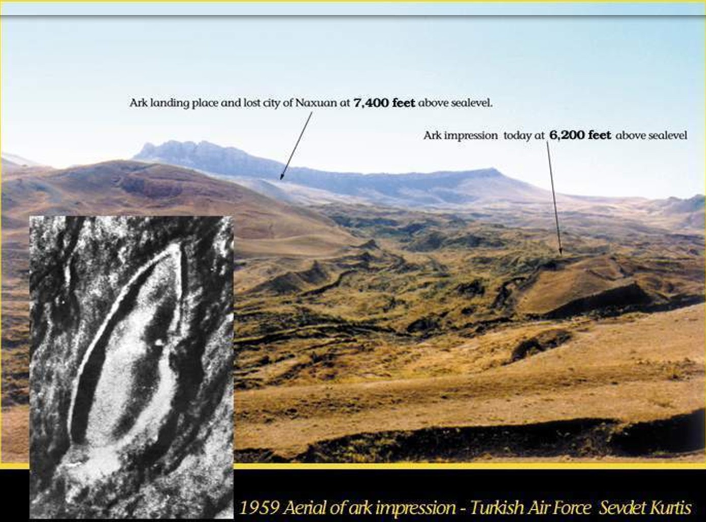
I was given a 1959 Turkish Air Force mapping photographic negative by Dave Fasold, which was given to him by Rene Noorbergen. It clearly shows the Ark stuck in the mud-flow. What attracted my attention was the fact that it was impaled on a large rock outcrop. My reasoning was that it must have slid down from higher up on the mountain, which indeed it had. I made a 16″ x 20″ enlargement of a 3″x 5″ section of the negative and soon found the impression where the Ark had originally touched down. Here was a clear outline, highlighted by the sun, of the berm created by the great ship, lying hard against a thirty foot high escarpment of limestone where Noah had landed her. The outline was precisely the same shape and size of the Ark-mold a mile farther down the hill and 1,200 feet lower where it had obviously slid after many years -perhaps by earthquake and rain to soften the earth. One may see this in the accompanying 1959 photo. This detail had not been previously noticed.
 Notes 64: This is one part of the enlarged photographs taken by Sevkit Kurtis (Air Force pilot) in 1959. Purple arrows are the mud flow path that ends in a circle representing the ark area. The upper part, which is a white plateau is Iran and under the steep cliff (cliff shadow) is Turkey. Down at the bottom, right in the convergence of several mud, looks ark elliptical. The size of the ark nearly the size of two football fields, it appears small in this photo, where the distance from the top to the bottom of the image is almost two miles. For size comparison, Noah’s Ark is no longer than RMS Titanic, but it is wider.
Source Image: noahsark-naxuan.com
This led me to send a copy to Professor Salih Bayraktutan with Dave Fasold for further evaluation. Later, I made an even larger blow-up and began to see hundreds of house foundations. In the final analysis, there were at least a thousand still visible rectangular depressions in the area. Here was the long-lost city of Mesha- Naxuan, referred to in the Bible (Genesis 10:30) and by Gilgamesh as the “Mountains of Mashu,” where Noah and the flood survivors built the first city. Other writers have also mentioned it, they include Claudius Ptolomy, Josephus, and Armenian historian, Moses of Chronensis.
 Notes 65: The map created by Deal using photogrammetric methods derived from aerial photographs mapping the Turkish Air Force (pilot Sevket Kurtis) in 1959. Appear on the map seen many houses (rectangular) from the old town ‘Mesha (Naxuan)’. This is where Noah’s Ark was stopped (down) of berthing places in the Mount Judi (see box blue-gray). Small dark blue box is the position of Professor Bayraktutan (see photo below).
Source Image: noahsark-naxuan.com
 Notes 66: Photo taken in 1998 by Professor Robert Michelson of Georgia Tech, in the first expedition to Naxuan, shows Dr. M. Saleh Bayraktutan, professor of geology at the University of Atatürk, Erzurum, stands on the foundation stones of one of the ancient settlements in central Naxuan near the landing site of ark, at an altitude of 7,400 feet above sea level.
Source Image: noahsark-naxuan.com
The name for the mountain “Cudi” makes reference to the first and longest lasting inhabitants the Kurds. Josephus claims that the ark landed in the mountains of “Cordyaeans” meaning Kurds. The actual name of the mountain is Cudi Dagi which means “mountain of the Kurds.” In Hebrew the word kHD (Strong’s # 2298) means “first.” Cudi was the first landfall, the first human habitation, and the present inhabitants still refer to themselves as Kurds. The Kurds at some past time must have seen themselves as the first people in the area. Thus the importance of the original name of the mountain, phonetically “kHudi” cannot be over- stressed. (Judi is a Turkish and Arabic pronunciation based on the difficulty in pronouncing the Shemetic kH (cHayth) used at the time of Noah. It is a gutteral explosive growl sound. It may be transliterated as C, Kh, Ch, and perhaps has even crossed over to Jh, as the evidence seems to suggest, hence “Judi.” is an early Chaldeanattempt at vocalization. (because Berosus made the claim first).

 Notes 67: By: http://www.noahsark-naxuan.com/
 Notes 68: It appears the location of the Durupinar Site (Noah’s Ark written by squidoo.com) at the base of Mount Judi seen in the viewing angle of the Ararat Mountains (culminating snow). Image left was taken on the mainland, while the right image when seen from the air.
Source Image: squidoo.com
Archaeology on the mountain has begun as of this October 1999, as a result of our two field investigations (1998 and 1999) under the aegis of the Ataturk University in Erzurum with professor Bayraktutan in charge of investigations. I am proud to say that the professional academic attitudes of arrogance with respect to non-professionals are not visible in Turkey as they are in America. A nonprofessional has discovered the world’s prime archaeology site the first post-flood city of Naxuan, and the professionals actually have taken the time to have a look at it and the result is an official archaeology project has begun. Shades of Heinrich Schleimann of Troy and Micnae!
Lastly mention must be made of the hundreds of thousands, perhaps millions of graves that also show up in the photograph. Suffice to say that three human ribs were legally exhumed from a reliquary burial in the upper city region near the ark touch-down point in October, 1999 by SEPDAC (an international scientific organization established to investigate the region’s early post diluvial culture). These relics along with pieces of the pottery container are presently in the United States awaiting dating measurement funding.
 Notes 69: Two early fire pit (sunken hearth) was found in 1998 by an expedition organized SEPDAC to verify the discovery of the lost city [Naxuan (Mesha)]. Noahsark-naxuan.com say that this is one of the furnaces of the three sons of Noah, because there are only two of them discovered in the vicinity of the ark landing place. As the Book of Genesis 6:10, Noah begat three men: Shem, Ham, and Japheth. This is somewhat different from the Tafsir Ibn Kathir says that Noah had four children, namely: Ham, Yafis, Sam and Yam, which Yam eventually scuttled by God because rebel [see QS. 11:42-43].
Source Images: noahsark-naxuan.com
With respect to Naxuan, Moses of Chronensis, quoted by William Whiston in his massive translations of Josephus’ work, states in a footnote on p. 29 (Antiquities of the Jews) that the city of Naxuan was “the place of the first descent.” This fits in well with the archaeological evidence thus far gathered, of a landing higher on the mountain, as indicated in the Air Force photograph, and a later downhill plunge of the Ark to its final resting place at the site of what later became the second city called “Seron.” In the same photo, the city remains are clearly visible next to the Ark. The term “place of first descent” is important because that second descent downhill is implied.
 Notes 70: In this photo from the south, you see what remains of Noah’s Ark (which is actually what you see here is an impression of the water line at the bottom – a mold that hardened soil, the sludge blackened). Impression of the end of Noah’s Ark is located at an altitude of 6,200 feet above sea level, on a mountain in Eastern Turkey, about a mile to the west from the border Turkey / Iran and 17 kilometers south of Mount Ararat. This hull-mold is not the Noah’s Ark in a complete state [this is also said by geologists Murat Avci in his book entitled “The Formation and Mechanisms of the Great Telçeker EarthFlow Which Also crept Noah’s Ark!, Mount Ararat, Eastern Turkey“], but the impression where the ark before the material is taken for wooden building materials and eventually rot a few thousand years ago. That timber ship many no longer exist, because many people are taken to use “cast out demons”. Hull-Mold of Noah’s Ark found in modern times in the month of May 1948 by a local (Kurdish) farmer named Reshit Sarihan after the series of three separate earthquakes that shook the ground around the site. In October 1998, David Deal was invited to Turkey by Professor M. Saleh Bayraktutan from Ataturk University, Erzurum, to see the claims of the invention. In the next three-year expedition, they confirm the claims of the discovery of the lost city of Noah (Naxuan). In Naxuan they find places to stay and a lot of signs of human occupation in a large scale at a depth of 7400 feet above sea level. There was also found the rib feet was about 70 years after the death of Noah (according to Professor Rob Michelson). Deal found the remains of Naxuan and Seron which are ancient cities after the floods after analyzing photos of the 1959 NATO Mapping by Turkish Air Force. Both cities had also discussed by ancient writers such as Berosus, Moses of Chronen, geographer Ptolemy, and Josephus. Translator, William Whiston, cites Armenian historian, Moses Chronensis, in ‘The Complete Works of Flavius Josephus’, in a footnote on p. 29 (Antiquities of the Jews), saying that this place is called “Naxuan, place of first descent”. The phrase “first descent place” implies the second descent, and that’s what this site tells us. Mesha-Naxuan is the city of “first” built by the flood victims and their descendants.
Source Image: powerpointparadise.com
 Notes 71: This illustration of the ark flow direction when down from Judi hill to Durupinar Site. According to Deal, after he discovered the lost city (Naxuan), he argues that the ark was definitely sliding down the hill and then lodged in the mud volcano near the village of Uzengili far as 2 kilometers (over one mile). In July 1997, when climbing to find the source of traces of mud, Deal saw another impression, identical in shape and size lower than ship-mold [Durupinar Site]. This then, is the landing place of the ark after the flood. Shortly thereafter, the foundation of the building began to appear under examination in this area of the photograph. Within a few days, nearly thousands foundation of the house has been identified. Mesha / Naxuan, the city of Noah, came to light after 4,500 years.
Source Image: squidoo.com
 Notes 72: The image above is the explanation of Deal to the boat landing stages that visible from the south of Urartu Mountains. Deal said that in this figure, the village Arzap seen on the right, where the ark was lying at anchor for nearly four months, and then on the left, 14 miles away, visible landing place of the ark, five kilometers east Dogubeyazit, the formation of non–volcanic upthrust (horst) of creataceous limestone. It is very different to Mount Ararat which is behind the display, which is an active volcano. Similarly, the formation of Mount Tendurek in southern Dogubeyazit often spouting lava, so both of Mount Ararat and Mount Tendurek may not be a port of Noah’s Ark. In addition, Deal also said that if it is said that at the time of resting in the territorial waters of Urartu (Village Arzap-Kazan), then ark is said to be stranded in the mountains of Urartu (as many people say), then this is not right, because the ark just waiting for the water to recede before finally heading to the Mount Judi (Masher Dag [Mt. Mesha/Mashu]) for berthing. What David Deal saying seems in line with the sound of Qur’an 11:44 {And it was said, “O earth, swallow your water, and O sky, withhold [your rain].” and the water abated, and the matter was ended, and the ark rested on Mount Judi.}
Source Image: noahsark-naxuan.com
 Notes 73: Shown in the picture above, mold ark which gives the impression that the ark was made of planks. Although the wood of the ark was much taken, but the remains are still there, as it appears in the image below.
Source Images: 6000years.org
 Notes 74: Shown in the picture above; petrified wood is left on the deck of the ark mold.
Source Images: 6000years.org
Also, in the Epic of Gilgamesh, when he got to Utnapishtim’s home (Noah) Gilgamesh had arrived at the “Mountains of Mashu.” The slope is still called Mashu-r to this day meaning “resurrection day.” Gilgamesh stated that there…”were the twin peaks as high as the wall of heaven that guard the rising of the sun,” peaks that he called “paps” or breasts. These peaks may be seen there at the top of the mountain, the twin peaks at either end of the great limestone escarpment that rises above Naxuan’s ruins directly to the east, that indeed “guard the rising of the sun” as Gilgamesh claimed. The northern peak is called Ziyaret which appropriately means “shrine” and is so delineated on modern maps. The southern peak is called Cudi Dagi (Judi).
The Uzengil or high limestone ridge “saddle” which is the main north/south escarpment is also called Yigityatagi which means “Hero’s anchorage or bed”.
 Notes 75: By: http://www.noahsark-naxuan.com
 Notes 76: By: http://www.noahsark-naxuan.com/Slide4.htm

Notes 77: Appears on the left picture; the location of Durupinar Site or Ship-Mold (written “The Ark”) which is located adjacent to the ancient city that was lost; Mesha/Naxuan (written “House & Altar”), and “Nasar” as shown in the right image. “Nasar” is the ancient name of the Uzengili village. The name “Nasar” seems to have a relationship with “Nisir” which is another name of Judi Dagh (Mount Judi) for the ‘Babel’ (Babylonian Peoples) and also mentioned in the Epic of Gilgamesh.
Source Images: specialtyinterests.net
 Notes 78: This is the actual map of “Mesha/Naxuan” through photogrammetric techniques performed by David Deal. Center of Mesha/Naxuan located at the geographical coordinates: 44 degrees, 18 minutes east longitude, and 39 degrees 23 minutes north latitude, about 2 kilometers from the end of the ark’s resting place. It appears also The Uzengil or high limestone ridge “saddle” which is a north/south of the main escarpment (also called Yigityatagi which means “Hero’s anchorage or bed”).
Source Image: noahsark-naxuan.com
 Notes 79: It’s 1941 military map of Dogubeyazit / Ararat region showing the area to the left (Arzap-Kazan) where the ship was docked for a few months at the time of low tide. Many stone anchors found here, near the modern village of Kazan. Prior to 1941 the village was called “Arzap” which in Turkish and Shemetic means “cling to the earth” (eretz-tsab). Rectangle that is enlarged on the right side shows the location of Mount Judi (Cudi Dagi) about 12-14 miles to the east, where Noah’s Ark came resting for the last time and the Mesha/Naxuan city built by survivors.
Source Image: noahsark-naxuan.com
Please make an honest evaluation of the evidence, remembering that nothing has been found on Mount Ararat, and emotions alone hold people to that mountain.
All the truth asks is a hearing.”
Much more information you can find at the Mt.-Cudi-Page of NoahsArkSearch.Com. Plans to travel to Mount Cudi has Dr. Charles Willis, California. In 2008 he planned an expedition, but probably it will fail because of the dangerous situation in the southeast of Turkey. He published his knowledge in the web: Ancient World Foundation. In the 1980s he went to Ararat four times, but then he began to believe that the landing took place on Mount Judi after a visit there in 1995, 1996 and 2004.